


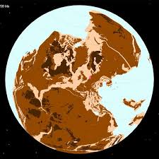
Your Backyard 320 Million Years Ago: The Paleolatitude Tool
A major update to the digital tool Paleolatitude.org was released in late April 2026, allowing anyone to trace the dramatic journey of their hometown across the globe. Developed by an international team led by Utrecht University, the tool uses 320 million years of geological data to show how continental drift has reshaped our world.
1. How the Tool Works: Mapping Deep Time
The website isn’t just a map; it’s a time-traveling calculator built on the Utrecht Paleogeography Model.
-
The Input: You enter any modern coordinate or city name.
-
The Output: It generates a graph showing how that specific “backyard” has drifted north or south (latitude) since the time of the supercontinent Pangaea.
-
The Science: Researchers reconstructed “lost continents”—landmasses that have since been folded into mountain ranges like the Himalayas or swallowed into the Earth’s mantle—to create a truly global picture.
2. A “Climate Time Machine”
This tool explains why we find strange fossils in unexpected places.
-
The Netherlands as “Arabia”: A famous example used by the researchers is a quarry in Winterswijk, Netherlands. Fossils found there from 245 million years ago look like they belong in a tropical desert.
-
The Proof: The tool confirms that 245 million years ago, the Netherlands was at the same latitude as the modern-day Persian Gulf. It wasn’t just that the world was warmer; your backyard was physically in the tropics!
-
Moving Poles: The tool also accounts for “apparent polar wander,” acknowledging that the Earth’s magnetic poles have shifted along with the continents.
3. Why It’s a Big Deal for 2026
While earlier versions of this tool existed, the 2026 upgrade is a massive leap forward in accuracy and functionality.
-
Three-Dimensional Biodiversity: Paleontologists are using it to see how mass extinctions affected different latitudes. For example, during ancient global warming events, which latitudes became “death zones” and which became “refuges”?
-
Marine Magnetic Data: The new model incorporates fresh data from the ocean floor, providing much higher certainty about the speed and direction of tectonic plates.
-
User-Friendly: The site now allows researchers (and curious students) to upload bulk data sets to see the history of entire fossil collections at once.
Earth’s Latitudinal Shift: A Quick Look
| Era | Timeline | Earth’s Layout |
| Carboniferous | ~320 Million Years Ago | Pangaea is forming; most land is clustered. |
| Late Jurassic | ~150 Million Years Ago | Pangaea begins to unzip; the Atlantic starts to form. |
| Late Cretaceous | ~70 Million Years Ago | Continents are recognizable but still close together. |
| Holocene | Present Day | The world map as we know it. |