


Drone Radar: The Future of Pinpointing Water on Mars
Scientists have unveiled a groundbreaking strategy for finding water on Mars: using low-flying drones equipped with specialized radar. A recent study, published on May 1, 2026, suggests that these aerial scouts could solve one of the biggest hurdles for future astronauts—knowing exactly where to dig for life-sustaining ice.
1. The Technology: Bridging the Gap
Currently, Mars exploration relies on two extremes: orbiters that see the big picture and rovers that analyze a single spot.
-
The Problem: Orbiters can detect massive ice deposits but can’t tell if that ice is buried under one meter of dust or ten. Drilling blindly is risky and energy-intensive.
-
The Drone Solution: Drones can fly much closer to the surface, allowing their Ground-Penetrating Radar (GPR) to map subsurface structures in high resolution. This fills the “information gap,” helping mission planners select the most accessible drilling sites.
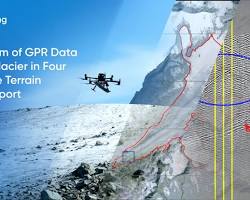
2. Testing on Earthly “Mars Analogs”
To prove the concept, researchers from the University of Arizona tested the drone-radar system on Earth-based glaciers that mimic Martian conditions:
-
The Locations: Sourdough Rock Glacier in Alaska and Galena Creek Rock Glacier in Wyoming.
-
Debris-Covered Ice: These glaciers are hidden under layers of rock and sediment, just like the ice deposits found in Mars’ mid-latitude regions.
-
The Result: The drones successfully mapped the thickness of the debris and the internal structure of the ice. These findings were confirmed by physically drilling into the glaciers, proving the radar’s accuracy.
3. Why Water Ice is the “Ultimate Resource”
Finding accessible water is the key to long-term survival on the Red Planet:
-
Life Support: Water provides drinking supplies and can be split into hydrogen and oxygen for breathable air.
-
Fuel: Extracted water can be converted into rocket propellant for the journey back to Earth.
-
Astrobiology: The internal layers of these glaciers act as a climate archive, potentially preserving evidence of ancient Martian life or past environmental cycles.
4. A Layered Exploration Strategy
Researchers envision a three-tier approach for future missions:
-
Orbiters identify broad, ice-rich regions.
-
Drones (inspired by the success of the Ingenuity helicopter) fly low to refine those maps and find the shallowest ice.
-
Human or Robotic Landers arrive at the “X” marked by the drone to begin drilling and extraction.